Monitor Long Island Traffic in Real-Time
Access 800+ live traffic cameras across Nassau and Suffolk counties — where 7.5 million people share a narrow 118-mile island with some of the most congested corridors in the Northeast. Our interactive map provides real-time access to live street feeds and intersection cameras throughout the North Shore and South Shore villages. Monitor the Long Island Expressway, check conditions on the Southern State and Northern State parkways, and track traffic on Sunrise Highway and the Meadowbrook Parkway.
VIEW LONG ISLAND CAMERAS →Watch live
Click any camera to open the live feed. Static thumbnails refresh periodically.
Coverage Areas
Nassau County
400+ Live Cameras
Northern State Parkway, Southern State Parkway, Meadowbrook Parkway, Wantagh State Parkway
Suffolk County
400+ Live Cameras
Long Island Expressway (I-495), Sunrise Highway, Route 25, Sagtikos State Parkway
Key Corridors
Long Island's east-west orientation funnels virtually all traffic through a handful of critical corridors. Understanding these routes is essential for navigating the island efficiently. According to a 2016 study, Long Island residents face some of the most challenging commutes in the nation, with an average one-way travel time of 33.0 minutes—a figure that frequently exceeds two hours for "super commuters" traveling from eastern Suffolk County into Midtown Manhattan.
Long Island Expressway (I-495)
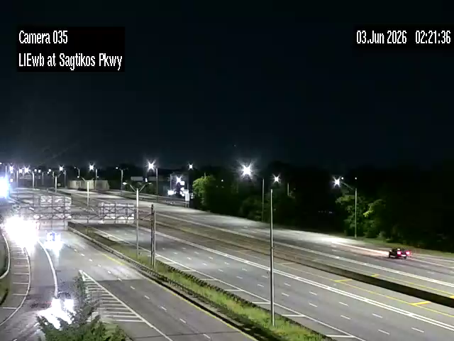
The LIE is Long Island's primary limited-access highway, stretching 71 miles from the Queens-Midtown Tunnel in Manhattan to Riverhead in eastern Suffolk County. Known locally as "the world's longest parking lot," the LIE handles massive daily volumes; according to NYSDOT traffic census data, western sections of the highway process approximately 210,000 vehicles daily, while segments in Nassau County see about 190,000. Congestion is heaviest between exits 30 and 49, where traffic from the Northern State, Seaford-Oyster Bay Expressway, and Sagtikos State Parkway merge.
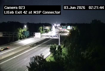
The corridor carries 90+ live cameras from the Queens border through the Sagtikos Parkway interchange to the eastern Suffolk approaches at Riverhead. The highest-leverage indicator for the Nassau-to-Manhattan westbound morning commute is the camera at the Northern State merge near Exit 42 — that's where Nassau-bound and NYC-bound traffic combine into the chokepoint that sets the tone for the rest of the morning.
Research from the Federal Highway Administration (FHWA) indicates that access to real-time traveler information systems can reduce incident-related delays by as much as 40% by enabling drivers to avoid bottlenecks before they become trapped in localized gridlock.
Southern State Parkway
Running 22 miles through Nassau and into western Suffolk County, the Southern State is a legacy parkway with low overpasses that prohibit commercial vehicles. Safety remains a paramount concern for local planners; Long Island leads New York State in traffic fatalities, with Suffolk County recording 164 deaths in 2022 alone. The interchange with the Meadowbrook Parkway near Hempstead Lake State Park and the merge at Valley Stream near the Belt Parkway are consistent bottleneck points.
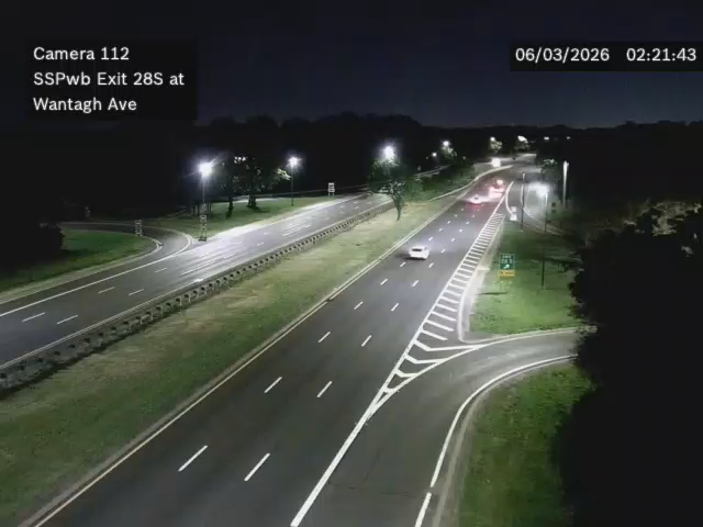
The corridor's 45+ cameras cluster densely between Exit 13 (Central Avenue) and Exit 28 (Wantagh Avenue), where the Meadowbrook merge produces the parkway's most-reported daily backup. The Exit 28 camera at Wantagh Avenue gives the earliest read on whether the South Shore commute will hold up — backups visible there are already past the point where alternate routing helps.
Northern State Parkway
Paralleling the LIE to the north, the Northern State runs 24 miles from the Grand Central Parkway in Queens to the Sagtikos State Parkway in Commack. Like the Southern State, it bans commercial vehicles and has lower clearances. Traffic cameras along this route help commuters monitor conditions at the Meadowbrook and Wantagh parkway interchanges, where merging traffic from the North Shore and South Shore creates predictable slowdowns. Users can also monitor live street feeds along Old Country Road and Jericho Turnpike to check for road-level gridlock near the major malls or local events.
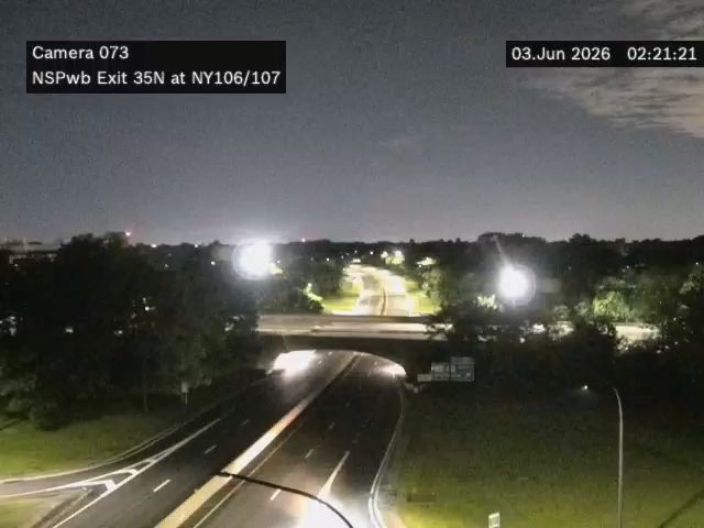
The route's 30+ NSP cameras concentrate around the Route 106/107 crossroads (a major shopping and event corridor) and the Wantagh Parkway interchange. For drivers using the NSP as the LIE alternate during morning closures, the camera at Route 106/107 is the cleanest read on whether the parkway has its own backup yet or is still moving.
Sunrise Highway (NY 27)
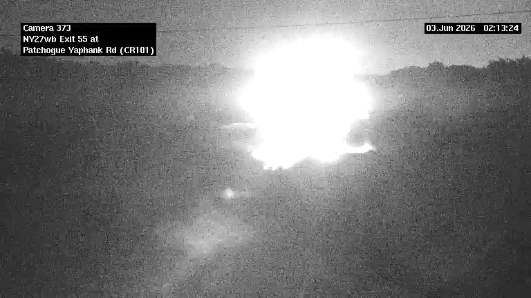
Sunrise Highway runs nearly the full south side of the island, threading east from the Brooklyn-Queens border through Nassau and Suffolk to the eastern Long Island fork near Southampton. It is the de facto Hamptons-bound corridor on summer weekends and the primary commuter route for South Shore Suffolk villages without LIRR access. The 40+ cameras concentrate around the Babylon-Bay Shore stretch (where the Robert Moses Causeway and Sagtikos cross) and again from Patchogue eastward into central Suffolk. The Patchogue-Yaphank Road camera is the high-leverage indicator for weekend Hamptons-bound flow — eastbound congestion that has built up there by 1pm on summer Fridays generally guarantees a 2-3 hour run to Southampton.
Meadowbrook State Parkway
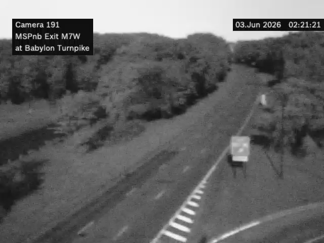
The Meadowbrook is Long Island's primary north-south parkway, connecting the Northern State and the LIE at its top end to Jones Beach and the Loop Parkway at its southern terminus. Like the other state parkways, it bans commercial vehicles. The 15+ Meadowbrook cameras cluster heaviest around the Southern State interchange (the parkway's busiest merge point) and along the Jones Beach approach, where summer Saturday beach traffic creates a predictable late-morning northbound jam on the return. The Babylon Turnpike camera gives the earliest signal on whether beach return traffic has started building.
Track Your Long Island Commute
Build a custom route along the LIE, Southern State, or any Long Island corridor and see every camera along the way.
BUILD YOUR ROUTE →Rush Hour Patterns
Peak Congestion Times
Westbound: 6:00 AM - 9:30 AM (heaviest 7:00 - 8:30 AM toward NYC) Eastbound: 3:30 PM - 7:30 PM (heaviest 4:30 - 6:30 PM from NYC) Summer Fridays: Eastbound congestion starts as early as 1:00 PM with beach and Hamptons traffic
Long Island traffic follows a pronounced tidal pattern. Each weekday morning, hundreds of thousands of commuters funnel westbound toward New York City via the LIE, Northern State, Southern State, and the LIRR. The reverse flow occurs each evening. This predictable pattern intensifies dramatically on summer Fridays, when weekend beach traffic to Jones Beach, Fire Island, and the Hamptons overlaps with the regular evening commute.
The stretch of the LIE between Exit 41 (Route 106/107) and Exit 30 (Cross Island Parkway) is among the most congested in New York State during morning rush. In the evening, eastbound traffic backs up from Exit 33 (Shelter Rock Road) well into Nassau County. Real-time camera feeds let you gauge delay severity and decide whether to use alternate routes like the Northern State or surface roads through the North Shore villages.
Weather Impacts
Long Island's coastal position makes it vulnerable to weather conditions that rarely affect inland areas. Nor'easters can bring heavy snow and coastal flooding, particularly along the South Shore and in low-lying areas near the Great South Bay. Fog is common during spring and fall, reducing visibility on the exposed parkway sections. Summer thunderstorms can cause flash flooding on the Southern State Parkway, which runs through a natural drainage corridor.
Winter storms present particular challenges because Long Island's geography limits alternate routing. When the LIE slows to a crawl during a snowstorm, the Northern and Southern State parkways — which prohibit plows and salt trucks due to commercial vehicle bans — may take longer to clear. Traffic cameras become especially valuable during weather events, letting you see actual road conditions rather than relying on forecasts alone.
Check Current Road Conditions
View live camera feeds from across Long Island to see real-time weather and traffic conditions before you drive.
CHECK CONDITIONS NOW →Features

Interactive Map
View all Long Island cameras on an interactive map with real-time clustering

Grid View
Browse cameras in a filterable grid with search and sort options

Save Favorites
Bookmark frequently-used cameras for quick access

Live Updates
Real-time feeds from 511 and DOT systems

24/7 Access
Monitor traffic conditions any time of day or night

Mobile Friendly
Fully responsive design works on all devices
About Long Island Traffic Cameras
TrafficVision.Live provides free access to 800+ live traffic cameras throughout Long Island. Our platform aggregates feeds from New York's 511 system and Department of Transportation cameras, giving you comprehensive coverage of traffic conditions across Nassau and Suffolk counties. These cameras are part of the world's largest traffic camera directory with 140,000+ live feeds from 600+ sources in 130+ countries across all 7 continents.
Whether you're planning your commute, checking current road conditions, or monitoring specific areas for traffic congestion, our Long Island traffic camera network provides real-time visibility into the region's transportation infrastructure. View live feeds from major routes including the Long Island Expressway (I-495), Northern State Parkway, Southern State Parkway, and Sunrise Highway. These same live feeds power CamGuessr, a free game where you watch a random camera and guess its location on a map.
Our interactive map interface lets you quickly locate cameras near your route, while the grid view provides an organized way to browse all available feeds. Build custom routes to see all cameras along your commute, save favorites for instant access, and monitor multiple areas simultaneously to make informed travel decisions.
How many traffic cameras are available on Long Island?
TrafficVision.Live provides access to over 800 live traffic cameras across Nassau and Suffolk counties, sourced from New York's 511 system and DOT feeds.
Are Long Island traffic cameras free to view?
Yes, all traffic cameras on TrafficVision.Live are completely free to access 24/7 with no registration required.
What major highways have camera coverage on Long Island?
Camera coverage includes the Long Island Expressway (I-495), Northern State Parkway, Southern State Parkway, Meadowbrook Parkway, Wantagh State Parkway, Sunrise Highway, and Sagtikos State Parkway.
Can I monitor multiple Long Island cameras at once?
Yes, our grid view lets you monitor multiple cameras simultaneously — ideal for tracking conditions along your entire commute route during rush hour.
How often do Long Island traffic camera feeds update?
Most DOT and 511 traffic cameras update every few seconds, providing near real-time views of current road and traffic conditions.
Where can I find Long Island street feeds?
You can find live Long Island street feeds and intersection cameras by using our interactive map, which aggregates 511NY and DOT data for major surface routes like Hempstead Turnpike and Route 110.
Ready to View Long Island Traffic Cameras?
Check cameras and city street feeds before you leave and know exactly when traffic clears — no more guessing.
START VIEWING NOW →